Overview

Flag of the Distrito Federal
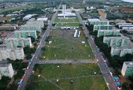
Unlike most cities, which simply grow haphazardly according to the lay of the land, Brasília was planned from the beginning. The architects Lúcio Costa and Oscar Niemeyer designed the city in 1956, laying it out in the form of an airplane. The residantial and commercial parts of the city are located in the wings, which stretch north and south. The national government is mostly found in the “cockpit”. The surrounding areas, including satellite cities such as Taguatinga, Núcleo Bandierante and Gama, are less exotically structured.
Brasília is located in the Distrito Federal, which corresponds to the District of Columbia in the United States. The Federal District is a rectangle carved out of the state of Goiás for the specific purpose of being a home for the national government.
The region is lightly forested, with large amounts of open country dominated by gently rolling hills. As a result, one of the things that Brasília is famous for is the panoramic views. When you climb into tall buildings and look out, as the old saying goes, “you can see forever.”
To the east of the city is Paranoá Lake, a large body of water. Many of the wealthiest people live on its shores and in rich neighborhoods around it. The famous Juscelino Kubitschek Bridge crosses the Lake.
Because most of the original government workers and officials came from Rio de Janeiro when the capital was moved to Brasília, a lot of the upper class people speak with an accent clearly related to the carioca accent, i.e. that of Rio. On the other hand, most of the laborers contracted to build the city came from the Northeast, and so the lower classes tend to speak with the nordestino accent, or that of the Northwest. Over the years this distinction has blurred, but not vanished completely.
Climate
The central part of Brazil, which includes Brasília and surrounding regions, is located at somewhat higher elevation than most of the country. As a result, temperatures are noticeably cooler than one would expect for the latitude. And dry. Even during Rainy Season, humidity is lower than in most of the rest of the country.
Note the term I just used: “Rainy Season”. In tropical regions, although there are technically the four seasons—spring, summer, fall and winter—the real difference is in how much rain falls. Temperatures are slightly cooler during the “winter” months, but not by that much. Instead, rainfall amounts drop dramatically, essentially stopping almost completely for several months.
During Rainy Season, thunderstorms abound. You can expect to be poured on nearly every day, accompanied by plenty of lightning and thunder. In fact, Brazil is the country with the highest incidence of lightning strikes in the world. Without adequate protection, electronic equipment will almost certainly suffer damage during Rainy Season. Puddles develop in low-lying regions and do not fully evaporate for weeks on end, until there is a lull (always temporary!) in the rain. Grass grows and everything turns bright green.
Dry Season is just the opposite. Days can pass without a cloud in the sky. Or you might see high, thin clouds. Or perhaps cumulus will build up, but never enough to form rain clouds. Occasionally, a cold front will come through, which can actually drop some rain, usually without lightning. An interesting fact is that, although the climate in Brasília is cooler than in places like Cuiabá, cold fronts are never as strong and never bring the temperatures down to the same levels as they do there.
Transportation
Brasília has a fairly extensive urban bus system. Unlike in some other cities, you do not get a free transfer within a terminal. Fares also vary, depending upon the route. The bus system covers not only Brasília itself, but the satellite cities in the Federal District.
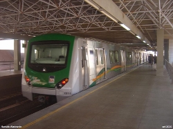
In addition, there is a Metro rail which goes from the central bus terminal to two different locations south of the city. The Metro is clean and modern and pretty fast, and the fare is comparable to a bus fare. Most of the system is underground.
There are two inter-city bus stations in Brasília. The one in the center of town—which is also one of the urban bus terminals and the terminus of the Metro rail system—serves a limited number of city destinations. The main rodoviária is located west of the main part of the city, on the highway that runs north-to-south and connects the main interstate highways. Here, you can get to just about anywhere in the country that you want, although for many places you will have to change buses in some city. This inter-city bus station is fairly new, having replaced the older one in 2011.
Taxis are available all over town.
Finally, rounding out the transportation options, there is an international airport, located at the end of the south wing of the city. Here, you can get flights to most parts of Brazil, as well as to quite a few other countries.
For private transportation, there are the city streets, of course. However, as described above, Brasília is laid out like an airplane, which makes for rather unusual street systems. The “fuselage” is a single, widely-separated multi-lane expressway that runs all the way from the “cockpit” to the north-south highway west of the city. The “wings” are laid out with a high-volume expressway running all the way from the north end of town to the south end, and with lower volume secondary expressways on either side. A complicated system of ramps—unfortunately, designed when vehicle speeds were considerably slower—allows you to exit these expressways into the “super-blocks” that make up the main divisions of the city. Within each “super-block”, the layout is essentially the same, so once you learn the system, you can drive in any part of town. Unfortunately, the system was designed by idealists with little concept of reality; it works, and makes sense once you get the hang of it, but it is neither intuitive nor convenient.
The satellite cities are laid out in more conventional fashion, although many sub-sectors have limited entrances that sometimes require drivers to go a long way to find.
Driving in the Federal District requires a slightly different mindset than for most cities. And there is a lot of traffic.
Shopping and Services
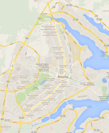
Map of Brasília
Being a major city and a national capital, there are a number of shopping malls in Brasília and the surrounding satellite cities. In addition, many major chain supermarkets and other stores have multiple outlets. Although the city still does not have the huge commercial market and resources of older, larger cities such as São Paulo and Rio de Janeiro, for the most part, “if you want it, you can get it.”
And, of course, there are the myriad smaller shops and stores that are found in any city, scattered all over the urban landscape. However, their locations do not follow the usual haphazard patterns found in most cities. Since Brasília is a planned city, divided into blocks and super-blocks, there is a “method to the madness”. Each super-block has certain parts that are reserved for commerce. Once you come to understand the system, you can go to any super-block and immediately make your way to the commercial sections. Furthermore, the original planners thought in terms of clustering shops selling the same basic goods in specific parts of the city; i.e. clothing stores would be found in one or more super-blocks reserved for clothing stores, electronics shops would be found in their own super-block(s), and so forth. Over time, fortunately for consumers, the lines blurred. But you can still find concentrations of similar shops in various parts of the city.
One thing to be aware of: the prices are high. While Brasília has the highest GDP per capita of all major Latin American cities, it also ranks among the top 20 most expensive places to live in the entire world.
Electricity is pretty reliable. Power failures are rare, even in outlying areas. Water is also pretty reliable. Internet service is also pretty good. As in most parts of Brazil, there are multiple telephone companies competing for service, which keeps the prices from soaring to astronomical heights. Unfortunately, residents of many of the outlying regions beyond of the actual urban limits still have few options.
A lot of goods and services arrived within the past few decades. When Brasília originally “opened for business”, it was still essentially a backwater town, so much so that diplomats assigned here considered it a hardship. After all, there weren't enough nightclubs to satisfy them! Even that, though, has changed over the years. Today, restaurants of all levels are available.
SIL Presence and Activity
For many years, SIL Brazil maintained an office/residence complex at the end of the North Wing of the city. The complex contained two apartment buildings for member residence, and an office building where everyone worked. This was the main entity headquarters, until it was closed in the mid-1990's, and the administrative functions moved to Cuiabá and Porto Velho. The office complex was sold, and a car dealiership took its place.
Today, SIL maintains a small presence in Brasília via an office on the first floor and basement of a commercial building in the North Wing of the city. Only a few people still work here, mostly in government relations and relations with other organizations. No direct translation project support is involved.
The office has a small computer network, consisting of a file server and router, and cabling to connect the few office computers to the network. On the first floor there is a small kitchen. Most of the actual offices are found on the basement level, along with equipment storage and network-connected printers.
Being located in the middle of the city, there are several good restaurants nearby that local workers and visiting members can go to in order to eat. In addition, one of the main north-south arteries—Avenida W3—is less than a hundred meters away, so transportation is not a problem.
ALEM
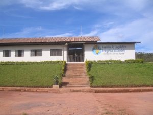
Main Office at ALEM Center
ALEM is SIL Brazil's principal partner in linguistics and translation. Since the mid-1990's, ALEM has maintained a center north of the end of the North Wing in a semi-rural sector called Granja do Torto. Like the former SIL center in Cuiabá, it contains both residential and work facilities, as well as a dormitory and dining hall for guests and students. The largest structure is the office building, which serves as ALEM's organizational headquarters and contains classrooms for the CLM course. A number of individual and duplex houses dot the center, along with a fairly new 4-apartment building.
For more about the CLM course, see the section on ALEM on the page about Wycliffe and SIL.
For more about some trips I made to provide service to our ALEM partners, see the following work trip reports.
An internal 220-volt distribution network provides electricity to all of the buildings. Internet service comes through a pair of DSL lines into the office building, where it is channeled via a gateway computer to both an internal wired network that serves the office, and several wireless routers to reach more remote parts of the center. After lightning repeatedly damaged both telephone and computer equipment, grounded protection was put in place and has done a fairly good job of keeping electronic equipment safe ever since.
Water is provided by a private well on the center, and distributed to all of the buildings. An internal telephone network connects to the central PABX and provides both internal and external communication.
The dormitory complex is actually two buildings, with a laundry facility and area with clotheslines in between. Both buildings have a kitchen area in addition to individual rooms and bathroom facilities. Across the road from the dormitory complex is the dining hall, where meals are served daily during the CLM course, and at certain other times, such as when there is a conference or some other special group of people visiting. The food is good, and everyone is expected to wash their own dishes and silverware.
There is also a maintenance building, a covered shelter for outdoor gatherings, and a soccer field.
Area Tourism
The major attraction of Brasília tourist-wise is the national capital and the architecture. Structures such as the National Cathedral draw many visitors every day. Along the “fuselage”, just west of the government center in the “cockpit” is a TV tower where visitors are permitted to take an elevator to a platform where they can take in the grand view. The Brasília Zoo draws many visitors, along with the City Park, and there is a Botanical Garden on the east side of the Lake. Still, the majority of visitors come for business, not pleasure.
However, the surrounding state of Goiás has a lot of tourist attractions. Places like Pirenópolis and Corumbá—small, historic and tourist towns—attract many visitors, and are an easy drive from Brasília. Chapada dos Veadeiros National Park lies a ways north of the Federal District. A number of waterfalls and scenic overlooks can be found in the area.