Overview
Road Trip '86 was the first of the many camping trips I have taken. Actually, the original idea wasn't so much a camping trip as just a chance to hit the road and see parts of the country I had never seen before. Believe it or not, I got the original idea from the movie Animal House, a rather bawdy flick I was conned into watching by some friends back in my college days. Most of the movie just “went in one eye and out the other”, but one thing stuck. At one point, a few of the main characters decided that they needed to just get away from it all for a few days. They looked at one another and said “Road Trip!” in unison. Then they just hit the highways.
Never being rich, when I decided that I needed to “get away from it all” for a bit, I realized that motels were not cheap. So I got out my old sleeping bag, bought a tent and some other odds and ends, and hit the road in my old Chevy Citation. I didn't really have any specific goals in mind; I simply decided to head west into California, then angle north and hit the coast around the Bay Area. Along the way I did such spur-of-the-moment things as taking a tour of a WWII submarine in San Francisco, driving along the Avenue of the Giants between San Francisco and Eureka, visiting Crater Lake, going to Expo '86, and making my first visit to Yellowstone National Park.
I learned that air mattresses are not to be trusted; the very first night the one I bought sprung a leak. I also learned to plan ahead and be prepared; I left Tucson, Arizona with the temps up near 100 with only a sweater and a light jacket. Needless to say, by the time I hit Oregon I really wished I'd brought something heavier.
I ate in restaurants. Later, I picked up such niceties as camp cooking and the use of ice chests, but hey, this was my first time! I only stayed one night in each campground. It was also later on that I learned the enjoyment and relaxation of settling in for a few days out in the wilderness. I hunted for campgrounds as I went. The days of the Internet were still in the future and I didn't have any resources for researching ahead. And even if I had I didn't know enough to use them then. It was a trip of many firsts. Fortunately, it wasn't the last.
One thing I did which I did not do on some later trips was to take a camera. I had a Kodak disk camera and ended up shooting 225 pictures during the whole trip. Of those, all but four turned out good. In the following sections, broken down by state, I will recap my journey, and include some of those excellent photos I took back then.
September 3 - 5: California
Wildernet – California
California Tourism
Although I began my trip in Tucson, AZ, I did not stop in my home state. Instead, wanting to get as far along as I could on the first day I went through Phoenix, angled up the secondary roads to Interstate 40, then headed west on into California. I spent the first night at a campground located in Calico Ghost Town County Park.
The next day I headed up the San Joaquin Valley. Normally a desert, irrigation has turned this place into a huge farmland, replete with crops. And even though it was already September, the temps were still quite warm. Toward the end of the day I left Interstate 5 and stopped for the night at a campground in the San Luis Reservoir State Recreation Area.
San Luis Reservoir
The campground lay behind me as I snapped this photo. This is only a tiny corner of the reservoir; it is quite large.
The next day I continued out toward the coast from I-5, and as I traveled I experienced an interesting phenomenon of the coastal regions; the temperatures dropped notably with each passing mile. By the time I reached Highway 101 it was cool. By the time I reached the Bay Area I needed a sweater.
Much has been said about San Francisco, both in story and song. Having never been there before (well, since I was a year old!) I made it a point to swing through such places as Chinatown and Fisherman's Wharf. The only reason I didn't stay longer was because the traffic was heavy and there was nowhere to park where they didn't charge you the price of your firstborn just to leave your car for an hour. Nevertheless, when I saw an old World War II submarine, complete with tour, I just couldn't pass it up.
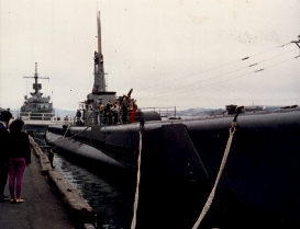
World War II Submarine
I can't recall the name of this sub, but it was the Real Article, a survivor of the war. The tour was fascinating.
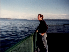
Also, having never been in San Francisco, I had never crossed the Golden Gate Bridge. As I left the city I made it a point to do so. As it turns out, they charge toll, but only going south! So since I was heading north, I got this one for free.
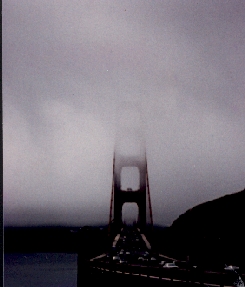
Golden Gate Bridge
The marine layer was particularly heavy this day, and the tops of the bridge towers were invisible in the clouds.
North of San Francisco, Highway 101 passes through a series of cities of decreasing size, until at last you are completely in the country. I passed by Humboldt Redwoods State Park, not even aware of its existence, and did not stop there. I eventually rectified this error during National Parks Tour '04. Nevertheless, I did stop and see some of the giant trees up close and personal.
That evening I passed through Eureka, a coastal town of moderate size in Northern California. Again, I experienced the temperature drop as I approached the shore. As I mentioned in the overview above, I was eating in restaurants on this trip. So, since I was on the ocean shore, what better thing to eat than seafood? I can still remember the delicious clam strips I had for supper.
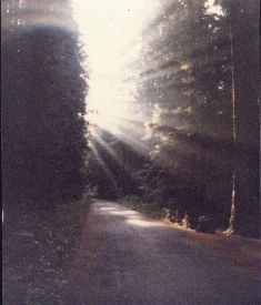
Night was falling as I headed inland, up into the mountains, looking for a campground. (Remember, this was pre-Internet days, so I hadn't been able to plan!) Then, just as it was starting to get dark, I spotted one and pulled in. The one remarkable thing I still recall about that campground was lying down in a large open space and seeing more stars in the sky than I had ever seen before in my life.
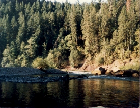
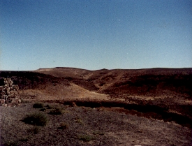
The next morning I picked up State Highway 96 in Willow Creek and headed north, wending my way along as the road paralleled the Klamath River, until it eventually left the forest and I came back to Interstate 5 and turned north, toward Oregon.
Klamath River
Highway 96 runs parallel to the river. This was just one of the places where I was able to enjoy a great view of it.
September 6 - 7: Oregon
Wildernet – Oregon
Travel Oregon
I had never been to the state of Oregon before, although I had friends who hailed from there. One thing that they never told me was that self-service gasoline is illegal! Apparently, someone had a dreadful accident at some time in the past (some idiot probably lit up a smoke while filling his tank and, ka-boom!), and so the state government reacted as governments so often do by enacting a blanket solution. On the other hand, the lack of a state sales tax is very nice.
As soon as I entered the state I made a beeline for the nearest big attraction of interest, Crater Lake National Park. I arrived on a comfortable day and spent a few hours walking along the shore and enjoying the view. It was enough to whet my appetite; the next time I visit I hope to camp a couple of days and see more.
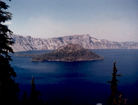
Crater Lake
The mouth of an ancient volcano, Crater Lake is extremely deep. The piece of land you see in the middle of the picture is called Wizard Island.
That evening I found a King's Table buffet restaurant and porked out, then backtracked around 20 miles to the campground where I had left my tent and sleeping bag all set up. It was a quiet little place on the bank of a river.
Oregon Campground River
I can't recall the name of the campground, but I spent the night here. I discovered the river while wandering around the grounds and came here in the morning to relax and enjoy the view before hitting the road.
I drove north up I-5 all the way to Portland, then picked up Highway 30 out to the coast. Highway 30 has an interesting bit of history for me; although I have never driven but a small fraction of its entire length, I have encountered this road in a number of places. I can recall driving along it in Indiana back when I used to live there!
I spent the night in a small, private campground on the coast, near Astoria. Since my clothes were mostly all dirty and the campground had washing machines, I took advantage of this and did my laundry. The next morning I headed up the coast on Highway 101.
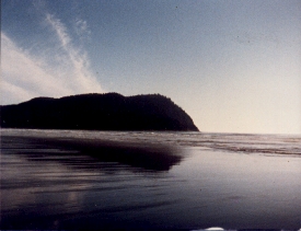
The Oregon Shore
The entire coast of Oregon is public land. You won't find any construction to mar the view. This was a crisp, cool morning with the smell of the ocean in the air.
September 8: Washington
Wildernet – Washington
Experience Washington
I had been in Washington state once before, for a conference in Astronomy when I was still a student at the U. of Arizona. I flew to Seattle that time, and found the climate change from 110 degrees and bone dry to 65 degrees and humid to be a shock to my system. This time I had had the chance to gradually acclimatize by driving, a mode of travel which I honestly prefer since it lets me see more of the country.
Highway 101 is unusual up in the Olympic Peninsula in that its direction changes. It makes its way up the Pacific side, then goes east along the Strait of Juan de Fuca, then turns back south again along the Hood Canal until it ends at Olympia. During its meanderings it passes through a section of Olympic National Park.
Crescent Lake
This banana-shaped lake lies just off of Highway 101 in a section of Olympic Park where you are not required to pay a fee to enter. It was a nice place to stop and stretch my legs.
In order to leave the Olympic Peninsula, I had two choices; I could either head south along 101 until I got to Olympia, then pick up I-5 again, or else I could hop over to Port Townsend on Highway 20 and take a ferry. Which do you think I chose?
On the Ferry
Ferry boats are a common means of transportation in this part of the state where large bodies of water separate cities and towns.
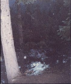
That night, I nearly ran out of gas. I was on a road heading east from Bellingham, looking for a campground, and the gauge was practically on fumes. I finally had to stop looking for a campground and start looking for a gas station! Fortunately, I found one, and at the same time the attendant told me where I could find a National Forest campground a little ways east.
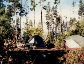
Morning at the Campground
I was taking a morning stroll and “just happened” to have my camera with me when I turned around and saw this.
The next morning I drove up a back road to a little town called Sumas, where I crossed the border into Canada to go visit Expo '86.
September 9: British Columbia
Travel BC
This border crossing was probably the easiest I have ever made heading north into Canada. A middle-aged fellow stuck his head out at the border and asked me what I was coming to Canada for. I told him I wanted to see Expo. He asked if I had any guns with me. I said no. He waved me on.
Expo was, well, interesting. At that time I hadn't had all the cross-cultural experience I've since acquired in my years with Wycliffe (see Billiard's Work). Seeing all of the nations and cultures represented here was fascinating. I spent more than an hour in the Chinese exhibit alone. I saw a mockup of a Soviet Venera spacecraft (the real one is still on Venus and rather hard to retrieve). And in the U.S. exhibit they had an actual Apollo space capsule and a real, honest-to-goodness moon rock!
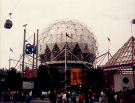
Expo '86
This big dome was one of the trademark sights of this World's Fair.
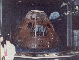
Apollo space capsule
This was an actual capsule that had been in space. I don't recall which one it was. You can see all the blackening and scorching from reentry.
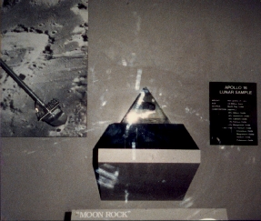
Moon Rock
The actual rock is encased in the plastic pyramid on top of the black base. It's kind of hard to see in this picture; I hadn't expected the glare when I shot the photo.
After visiting the Expo for the day, I traveled north and camped at Nairn Falls Provincial Park. It was dark when I set up my tent, and during the night, whenever I woke up, I heard a rushing noise. At first I thought it was wind in the trees, but I finally realized that it was water. The next morning I found that I had pitched my tent only ten feet from a 40-foot canyon with a river at the bottom! If I had gotten up in the middle of the night and strayed too far, it could have been a long fall.
River Canyon in Nairn Falls
I took this picture early in the morning before leaving. The first step is a doozy!
After leaving Nairn Falls I drove back down the coast and crossed back into the U.S.
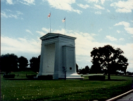
Border Monument
I took this shot while sitting in line waiting to cross back into the U.S. Note the flags on top; the Canadian Maple Leaf on the north and the Stars and Stripes on the south.
September 10: Washington
Wildernet – Washington
Experience Washington
Washington is a state of contrasts. The Cascade Mountains act as a barrier to the moisture that blows in from the ocean, causing it to dump all over the Olympic Peninsula and other western parts, and preventing it from reaching further east. I drove down from the Canadian border into Seattle, then crossed Lake Washington and went southeast through Mt. Rainier National Park. As you can see in the picture, everything was green, green, green…
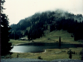
Lake east of Mt. Rainier NP
This lake lies in a valley below the highway. You can see a trail in the foreground. Note the clouds covering the trees at the top of the picture.
After I left Rainier I kept going east. I can still recall passing through a very short transition zone, and afterward I could have sworn I was back in the Arizona desert.
Central Washington
This part of the state is actually drier than the Arizona desert.
I camped that night in a KOA at Yakima. The next day I continued east toward Idaho.
September 11: Idaho
Wildernet – Idaho
Official Idaho Vacation and Travel Planning Guide
I passed through the “chimney” of Idaho, the narrow part in the north. Since evening was approaching, I stopped in the town of Coeur d'Alene for supper, then took a lakeshore road (Highway 97) south until I came to a campground to spend the night.
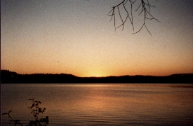
Sunset over Lake Coeur d'Alene
I took this photo minutes before taking the one below. No, they were not taken looking in the same direction!
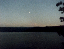
Moonrise over Lake Coeur d'Alene
A pleasant campground that I largely had to myself. Lake Coeur d'Alene is a moderate sized lake up in the chimney of Idaho.
September 12: Montana
Wildernet – Montana
Montana's Official State Website
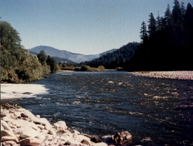
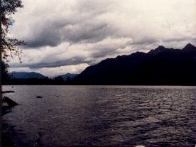
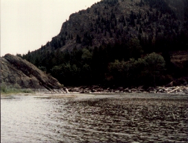
I didn't spend much time in Montana. That error I ended up correcting fourteen years later during Camping Trip 2000. I did stop a few times to see the countryside, and at one of those stops I snapped the picture below. I actually took several, but this was the one I liked the best.
River in Montana
I have no idea what river it was. I stopped to stretch my legs and liked the view, so I took the picture.
I did spend one night in the state at a campground north of West Yellowstone. I recall that it was probably the coldest night of my entire trip, and my anemic sleeping bag really couldn't keep up with the low temps. It was at that point that I made the decision to get a new sleeping bag when I got back home.
September 13: Wyoming
Wildernet – Wyoming
State of Wyoming
I entered the state of Wyoming through Yellowstone National Park. This was my first time in the park, and since then it continues to be one of my favorites. There was so much to see! However, foolish me, I didn't stay long. Again, I partially corrected that error during Camping Trip 2000, and later spent five days there during Rocky Mountain High '05
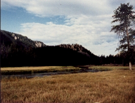
Firehole River
This river gets its name because it carries the runoff from the geysers in the southwestern part of Yellowstone. There is a place where you can swim in its warm waters.
I quickly discovered that there are many more geysers than Old Faithful. That one is merely the most famous. There are geyser basins all over the central part of the park. Warning: do not leave the wooden boardwalks while touring the thermal areas! The ground is thin and you can break through and fall into water hot enough to kill you. This is an extremely unpleasant way to die. The signs are there for a reason.
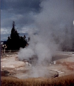
Geyser Basin
These thermal areas are very common. The central part of Yellowstone is actually a huge volcanic caldera. The nearness of the magma to the surface powers these phenomena.
Another thing that Yellowstone is known for is buffalo. All over the park you can find herds of the beasts. At times, they can block traffic while crossing the road. But since it's a national park, guess who gets priority? Anyway, who comes to Yellowstone just to race through? (The park speed limit, by the way, is 45 mph.)
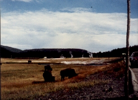
Buffalo and Geysers
Here you can see two of the things that Yellowstone is known for in one view.
Of course, what would a visit to Yellowstone be without at least stopping to see the most famous geyser. It is so popular that the park authorities have built an entire complex in the area, complete with hotel, restaurants, and much more. Being dirty from having camped for days in places without showers, I scrubbed up in Old Faithful Lodge. (I hadn't yet learned the trick of bathing in icy mountain water streams.)
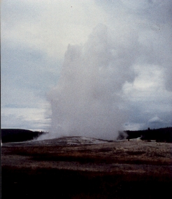
Old Faithful
The geyser was a bit late this time (predictions are posted for all to see), but when it came it was worth seeing. Beyond Old Faithful is an entire field of geysers, of which the famous one here is but one of many.
Much to my pleasure, I discovered that visitors to Yellowstone can also travel directly to Grand Teton National Park via the John D. Rockefeller Jr. Memorial Parkway, which connects the two national parks. Liking the idea of two parks for the price of one, I naturally went down to Grand Teton, where I ended up spending the night at the Jenny Lake campground.
Campsite at Jenny Lake
The black tent is mine. The other belonged to a young woman who was traveling like me. Since this was the last campsite available we agreed to split it.
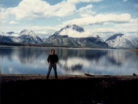
Jenny Lake and Grand Tetons
In the morning I decided to take the boat across the lake for a hike in the mountains. The young woman who split the campsite with me took this picture and came along on the hike.
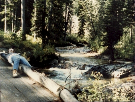
Resting on the Trail
I thought this would make a great picture. The trail here crossed a stream via a bridge as it wended its way up toward Cascade Canyon.
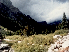
Storm Clouds Gathering
The young woman (I don't recall her name!) continued up the trail, but I headed back because I wanted to put some miles behind me that day. The storm you see over the mountains caught me before I got back to the boat, and I got soaked.
After the hike I left the park and headed south through Jackson Hole. An interesting item: Years earlier, there was a country rock band in Tucson known as Chuck Wagon and the Wheels. They had vanished a few years before I took this trip. Imagine my surprise when, while passing through Jackson, I see a marquee announcing, “Chuck Wagon and the Wheels”. Guess they had just decided to head north…
September 14 - 15: Utah
Wildernet – Utah
Utah Travel Site
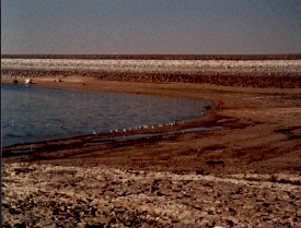
Utah is mostly desert. I spent one night at a campground in the mountains just east of Salt Lake City, then moved on. I learned that the Great Salt Lake is by no means the only one of its kind in the area. Indeed, some of the smaller lakes are even saltier.
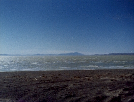
A salt lake
I don't recall the name of this lake, but it is supposedly one of the saltiest in existence.
In the south of Utah lies Zion National Park. Unlike the other national parks I had visited, this one is not known for forests and greenery. Rather, Zion is a place of rock formations. I ended up spending the night in one of the park campgrounds, and the next day spent a few more hours touring the sights.
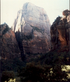
Large rock formation in Zion
This was merely one of the many huge formations that this national park is famous for.
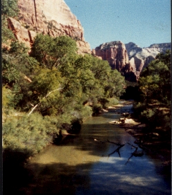
Stream in Zion
Although Zion is known mainly for its rock formations, it is not a complete desert, as you can see here.
After I left Zion, I drove east, then turned south and crossed the border back into Arizona.
September 16: Arizona
Wildernet – Arizona
Arizona Highways
Back home again. I had just spent a couple of weeks on the road, traveling thousands of miles, and was finally back in my home state. However, Arizona is big, and the day was not young by the time I crossed the border. So I ended up spending one more night in a National Forest campground somewhere between Flagstaff and Payson. Already, many campgrounds were closing for the fall. The air had gone from cool to cold, and I had the campground to myself.
The next day I drove through Payson, then into Phoenix, where I picked up Interstate 10 and headed home.
It had been a good trip. My appetite for more was whetted.