Overview

I first envisioned this trip when I was browsing on the Internet, looking for information on National Parks, and saw advertised the National Parks Pass. For only $50, I could buy a card that would allow me to visit any and all National Parks in the country for up to a full year.
So when I returned on furlough in May of 2004, one of the first things I did was to order a pass. I also acquired a vehicle, a used Dodge Grand Caravan, which I modified by removing the middle seat and putting in a shelf. With my experiences from my previous long trip in 2000, I was able to plan better this time how to go about camping, arranging supplies, etc.
One of the other things I purchased before starting this trip was a Canon PowerShot A300 digital camera. On this page you will see some of the pictures I took during this trip.
June 7 - 9: South Dakota
Wildernet – South Dakota
Travel South Dakota
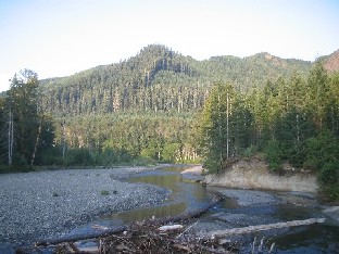
I left Wisconsin on the 7th of June, heading west through Minnesota and on into South Dakota. At the end of my first day's journey I was near Walker's Point State Recreation Area, a place I had stayed at back in 2000. So I stopped there to spend the first night of this trip.
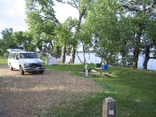
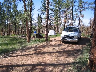
Walker's Point Campsite
Here is the campsite I stayed in at Walker's Point SRA. It was either the same site as the one I stayed at in 2000, or else one of its neighbors.
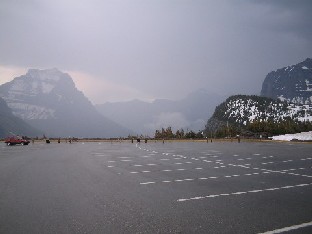
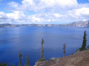
The next day, I got back on Interstate 90 and continued west. The weather had turned windy overnight, blowing sharply out of the north, and by the time I reached Badlands National Park, it was quite chilly.
Badlands was the first park I visited, so it was here that my pass was activated. The first thing I did was to make my way to the Cedar Pass campground, set up my tent, and reserve two nights. Once that was done I left to see some of the sights in the park.
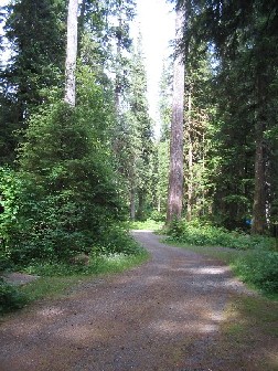
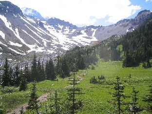
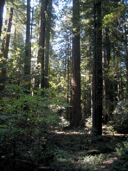
The first place I visited was the Cliff Shelf Nature Trail. This was a small loop at the foot of a cliff, which climbed into some scrub trees and, in general, gave the visitor a sample of the Badlands.
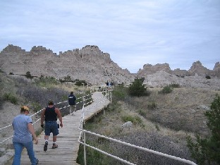
Cliff Shelf Nature Trail
Most of the trail was on boardwalk like this. Here you can clearly see the carved cliffs that are so typical of the area.
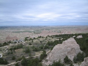
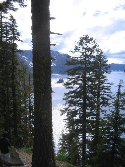
Afterward, I went up the road a ways to a parking lot where several trails lead from. While there, I looked around, then hiked up the Notch Trail to the top. The view was quite spectacular!
View from Parking Lot
This is the view from the parking lot where several trails lead from. The Notch Trailhead is to the right.
Notch Trail
This is a shot of part of the upper section of the trail. Up ahead, it descends a steep ladder and turns almost a hundred and eighty degrees to go back to the parking lot.
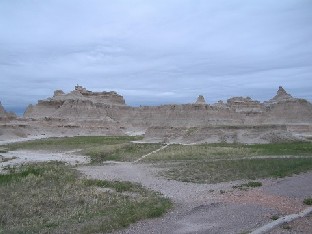
Notch Trail Overlook
This is a view from the “Notch”, from which the trail gets its name. Down below you can see the Cliff Shelf Nature Trail.
When I left this area I drove west a bit and stopped at an overlook near the Fossil Trail and took a short hike. Since I had been here in 2000, I didn't stay long; it was nothing new.
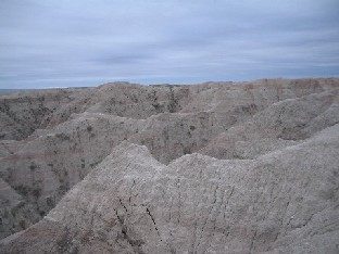
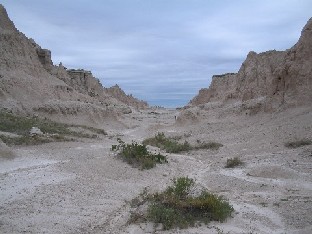
Fossil Trail Overlook
This is a view of the jumbled Badlands as seen at the Fossil Trail. It almost looks like an alien planet!
The next day I took a longer hike of several hours. However, since the weather was damp and drizzly, I did not take my camera. So I don't have any photos to show here. Sorry!
June 10 (day only): Wyoming
Wildernet – Wyoming
State of Wyoming
After leaving South Dakota I passed through the northeastern corner of Wyoming. One reason for doing so was to have a chance to see Devil's Tower National Monument. This unique geological feature was featured years ago on the movie Close Encounters of the Third Kind as the place where the huge alien ship landed. (If you wonder why I would remember such a detail, see the section on Science Fiction!)
At any rate, this was the first time I would pass close enough to see it, and since my Parks Pass covered the entrance fee, I took the necessary side road and stopped in for a visit.
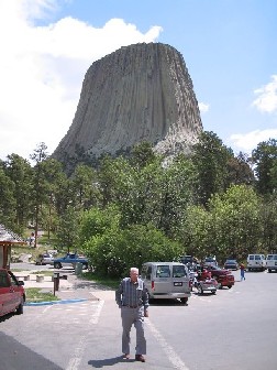
Devil's Tower
This is a view of the tower as seen from the parking lot at the visitor center.
While there, I took a quick hike around the base of the tower. This was a mile long trail which circumnavigates the tower and also gives views of the surrounding countryside.
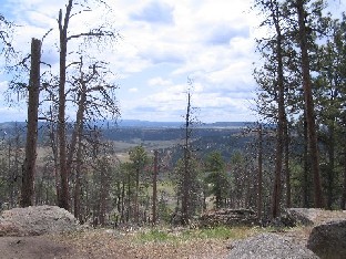
View from Tower Trail
This is a shot of the surrounding countryside as seen from the Tower Trail. As you can see, the lower elevations are mostly open plain, although the area around the Tower itself is forested.
Because I wanted to get to a campground in Montana that same night (and still needed to find it!), I left shortly afterward.
June 10 - 15: Montana
Wildernet – Montana
Montana's Official State Website
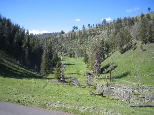
The first place I stayed at this time in Montana at was Red Shale campground in the Custer National Forest. I had known from the Custer website that there were campgrounds, but there was no information as to how to find them. Fortunately, Red Shale is directly upon Highway 212.
Campsite at Red Shale
The campground was situated on the top of a rise. To the right, out of the picture, was a stretch of wood that had suffered a fire.
I spent three nights at Red Shale, leaving the morning of June 13th. Continuing west, I came to the junction of Highway 212 with Interstate 90, and right at the junction was the Little Bighorn Battlefield National Monument.

Last Stand Hill at Little Bighorn
The memorial you see at the top of the hill marks a mass grave, the site of Custer's Last Stand.
Visiting the Little Bighorn monument was a sobering experience. Usually, I go to visit National Parks to experience something of nature, something grand and glorious. There was nothing glorious about a battlefield, replete with gravestones to remind one not only of violent death, but of the entire sad chapter of the way Europeans dealt with the native inhabitants of America. Nevertheless, if you are ever in the area, I strongly recommend a visit. There are more reasons for going places than merely grand scenery. This was a part of our history.
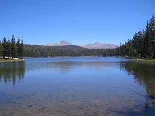
Later that afternoon I turned off of Interstate 90 into a local mountain range north of Bozeman, where part of the Gallatin National Forest was located. I had been here back in 2000, and once again I sought out the Battle Ridge campground. This campground sits on a saddle of land around 6000 feet in altitude.
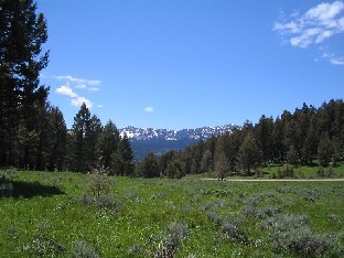
Mountains seen from Battle Ridge
This is a view from the open field between the campground (to the left) and the road. It was a clear morning, and the snow was shining on the mountains in the distance.
After three nights, I packed up and headed south to Yellowstone.
June 16 - 19: Wyoming
Wildernet – Wyoming
State of Wyoming
My entire time during this visit to Wyoming was spent in Yellowstone National Park. This was my third visit to this park, and my longest. Back in '86 I had taken some pictures; this time I took a lot more.
Like the last time, the first thing I did was to get to a campground, select a site, pitch my tent, and reserve a place for the next three days. This time I stayed at Norris campground, located near the Norris geyser basin close to the middle of the park. Its location made it a natural, centrally located spot to go out and visit park attractions from.
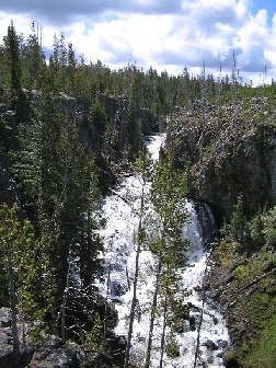
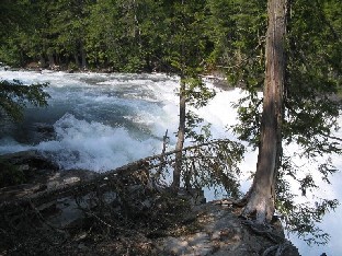
I first headed up to the northeast entrance. My reasoning was that I could not do the complete loop due to road construction, so I would go as far as I could, then work my way backward. I made it as far as Tower Falls the first day, then returned the next day and worked my way backward from there. Here are a few samples of things I saw.
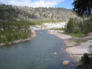
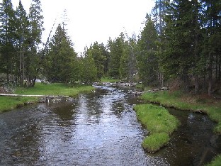
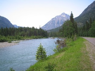
Yellowstone River
This shot of the Yellowstone River was taken near the Tower Falls. I would have included a shot of the falls themselves, but I couldn't get a close up because the trail was closed.
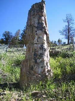
Petrified Tree
This stone remnant of a tree lies a bit west of the road to the northeast entrance. The thing that surprised me was that it stands alone. Why isn't there a petrified forest?
Canyon to Lost Lake
This picture is essentially a hundred and eighty degrees around from the previous one. A trail runs down this canyon and around the bend, leading to a small lake called Lost Lake.
Afterward, I made my way west to Mammoth Hot Springs. Here are a couple of things I saw there.
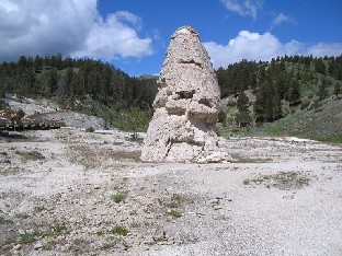
Liberty Cap
This cone shaped formation is the result of a hot spring that erupted powerfully for a long time, allowing deposits to build up around its base.
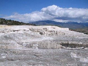
Terrace at Mammoth Hot Springs
This is just one of several terraces found at Mammoth Hot Springs. Hot, mineral-laden water cascading over small cliffs created buildup, resulting in this kind of formation.
After leaving Mammoth Hot Springs, I went down to the geyser basins on the lower loop. First, I went to the Upper Geyser Basin, where Old Faithful is located. Since I have seen Old Faithful erupt every time I've been here, and since I already had a picture of it, I did not wait for it to go off, but rather, went out to see the rest of the basin, camera in hand.
Firehole River
This is a picture of the Firehole River where the trail goes up into the woods behind Old Faithful. A bit different than the usual view.
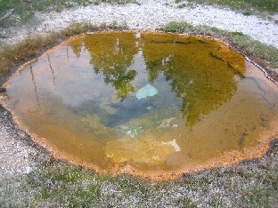
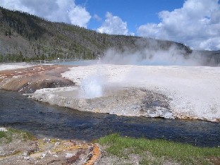
Colorful Pool
This is one of the many hot springs found in the basin. The reddish color is due to bacteria that live in the hot mineral water.
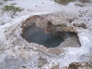
Scalloped Spring
This is Scalloped Spring seen up close, which resembles a black mouth. I could hear a deep underground hiss and smell sulfur fumes, indicating that it was definitely active to some degree, although it doesn't erupt like a geyser.
After leaving the Upper Geyser Basin, while driving along the road I had to suddenly stop when a barrier appeared in the road. Fortunately, the “barrier” quickly moved off. Here it is.
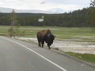
Buffalo in Road
I took this picture of this “road hog” after it had moved out of my lane. As you can tell, I shot through the windshield.
On the other side of the south loop is a place called the Mud Volcano. The springs aren't as wet and hot as at the geyser basins; mainly, you see pools of bubbling mud.
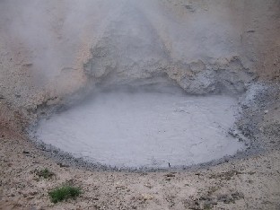
Mud Volcano
This area was full of pools like this one, large and small. This is the one actually called the Mud Volcano.
At the south of the loop, at the west end of Yellowstone Lake, lies the West Thumb Geyser Basin. This basin is relatively new; at one time the park authorities were constructing buildings in the area, and they had to give up when the ground began to erupt with thermal features.
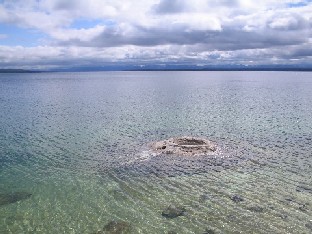
Crater in Lake
This is one of a few cones at the West Thumb basin that is actually out in the lake.
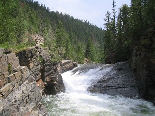
I spent a couple more days in the park and took some more pictures as I saw more sights. Here are a few of them.
Kepler Cascades
This is a small waterfall on the Firehole River, just south of Old Faithful.
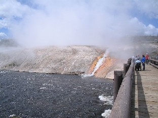
Cliff Geyser
This is a small geyser at the edge of Iron Creek in the Black Sand Geyser Basin, just west of Old Faithful. Iron Creek runs into the Firehole River.
Firehole River
This is the Firehole River at Midway Geyser Basin. The basin lies on the opposite side from the road; the footbridge is for visitors to go see the geysers.
That concludes my visit to Yellowstone National Park. This park, the oldest in the National Park system, is still one of my favorites and I will gladly go back again. (See Rocky Mountain High '05 for my return to Yellowstone.)
June 20 - 28: Montana
Wildernet – Montana
Montana's Official State Website
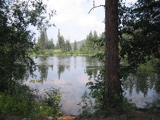
After leaving Yellowstone, I made my way north, spending a few days at Canyon campground in the Gallatin National Forest, then a night at Jumping Creek campground in the Lewis and Clark National Forest. Then I headed north to Glacier National Park.
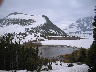
Glacier is another of the crown jewels of the National Park system. I came in through the east entrance at St. Mary's, then drove west along the Going To The Sun road, up through Logan's Pass, and down the other side, where I checked in at Avalanche campground and registered for a couple of nights. I had heard that the weather was foul, and decided to wait until the next day to decide if I would stay longer. After setting up camp, I headed out, continuing west.
Lake McDonald
A view of the lake, looking west.
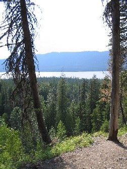
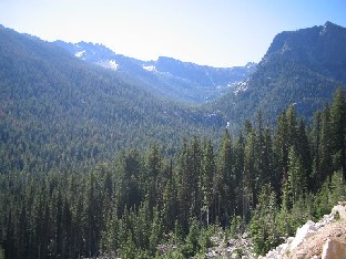
View from Sperry-Gunsight Trail
This is a shot I took from along the Sperry-Gunsight trail. The trail continued for a long distance, but I only went a little further before turning back. Lake McDonald is in the distance.
McDonald Creek
This river empties into McDonald Lake. This is a shot of the creek with mountains in the background, looking east.
The next day I continued my explorations heading east. The weather was quite cloudy in the morning, and instead of clearing turned into strong rain, which continued past noon. Nevertheless, I pressed on.
On Road East
I stopped and took this picture while traveling east in the morning. Note the clouds. A little while later they were dumping rain.
Logan's Pass
Here you can see, from the parking lot at Logan's Pass, the rain that had been approaching and building.
While at Logan's Pass, I decided to brave the rain and take a hike on the Hidden Lake Trail, which heads up into the hills behind the visitor center there.
Hidden Lake Trail
This little pond isn't Hidden Lake, but it is visible from the trail. This part of the trail lies behind the mountains seen from Logan's Pass.
After my hike, I went a bit further east. Finally, the rain made me decide to turn around and go back to the campground for a late lunch.
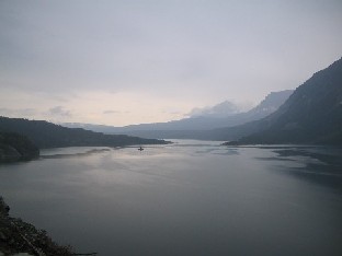
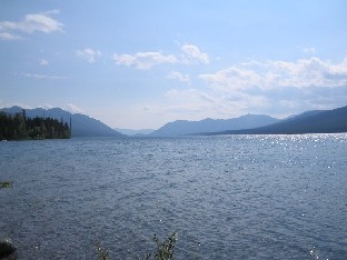
St. Mary's Lake
This is an even longer lake than Lake McDonald, and lies on the east end of the road. (I personally think that this is the best photo I took during the entire trip.)
While having lunch I asked one of the park employees about the weather, and she told me that not only would it rain again in the upcoming days, but that it would be even worse, lasting most of the day. This day, fortunately, it stopped around 2:00 in the afternoon, and I went back out, this time going west.
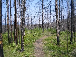
Camas Creek Nature Trail
This trail, at the very west end of the road, passes through a part of the park burned in the forest fires of 2003. As you can see, the vegetation is rebounding already.
Rapids on McDonald Creek
On the way back I stopped and took a hike along McDonald Creek, east of the lake. These rapids were one of the sights along the trail.
The following day I headed out. I felt that I had only seen a bit of the park, but I couldn't wait around for several more days for the weather to clear. So I made a vow to come back someday when the weather was better (did it in Combination Trip 2010), then got in my car and drove on.
I did make one more stop in Montana. Back in Camping Trip 2000 I had spent nine bucks to sleep one night at a campground in the Kootenai National Forest. Later, after some Internet research, I found another campground nearby, more isolated and quiet, that didn't cost a dime.
So I spent a few nights at Yaak Falls campground. Unlike Glacier, the weather was fine; one morning of drizzle was all. And a little ways upstream on the Yaak River was a small waterfall.
Yaak Falls
This small waterfall was about a quarter mile upstream from the campground. It was a relaxing place to sit and meditate.
Finally, after a few days, I packed up again and headed west, through Idaho and into Washington.
June 29 - July 14: Washington
Wildernet – Washington
Experience Washington
Washington remains one of my favorite states. The Olympic Peninsula, Mount Rainier, Puget Sound, the Cascades, and more are attractions that will always draw me to return. Maybe someday I will retire and move up there. (Though I confess to also liking Kalispell, MT!)
When I entered the state I got onto State Highway 20 and followed it west. About halfway across the northern tier of the state, in the Okanogan National Forest, was a small campground called Lyman Lake that I had visited back in Camping Trip 2000. It made a natural stopping place this time as well. I stayed a couple of days before embarking on the long drive west to the Olympic Peninsula.
Lyman Lake
The campground surrounds most of this small lake, which sits at around 4000 feet elevation in north central Washington.
When I left Lyman Lake I drove through the Cascade mountains, passing through Ross Lake National Recreation Area, which splits the two halves of North Cascades National Park. Since I was heading out to the Peninsula, I only stopped long enough to take some photos.
Cascade Mountains
The Cascades are an inland mountain range, east of the Coastal Ranges, but well west of the Rockies.
Once west of the Cascades I continued to the shores of Puget Sound, onto Whidbey Island, from where I took one of the Washington State Ferries over to historic Port Townsend. State Highway 20 ended shortly thereafter, dumping me onto the famous Pacific Coast Highway, US Highway 101.
Highway 101 is the only highway I know in which is marked North, then East, then South, all without the driver having to make any turns. It comes up the coast, runs along the Strait of Juan de Fuca, then turns south along the Hood Canal until it ends at Olympia. I turned south, along the Hood Canal, until I came to Skokomish Valley Road, which I followed several miles to a forest road, and then to the Oxbow campground, in the Olympic National Forest.
River at Oxbow Campground
The campground lies on a spit of land surrounded on three sides by the river, sort of like a peninsula. This type of bend in the river is called an “oxbow”, from which the campground gets its name. I had also stayed here during Camping Trip 2000.
I spent the Fourth of July at this campground. No, there weren't any fireworks. Fireworks are absolutely prohibited in every campground I visited on this trip. On the other hand, Oxbow is known to be a “party campground”. One of the forest rangers mentioned that they had had sufficient difficulty maintaining order here in 2003 that they had closed it early. There were some problems this year, but nothing as bad as before. For some reason this place tends to attract rowdy people. Nevertheless, sites are isolated enough that I was able to find peace and quiet.
After the Fourth, I left and headed south on Highway 101, then picked up Highway 8 going west, which dumps into Highway 12. Highway 12 terminates in the small city of Aberdeen, which lies at the head of Grey's Harbor on the coast. Finding a Pizza Hut open with a lunch buffet, I filled my stomach. Afterward, I rejoined Highway 101, this time going back north along the coast.
A little ways north of Aberdeen is a tiny wide spot in the road called Humptulips. A bit north of that, a forest road goes inland about 20 miles to Campbell Tree Grove campground. I had stayed there also in 2000, and now I returned to spend a few days.
Campbell Tree Grove
This is the road at Campbell Tree Grove campground. It is located deep in the Olympic rainforest, in a river valley. A fork of the Humptulips River flows next to the campground.
When I left Campbell Tree Grove I continued north. Where Highway 101 turned east I turned off onto State Highway 113, which I took to State Highway 112. Just west of a small town called Sekiu, on the shores of the Strait of Juan de Fuca, I turned onto the Hoko-Ozette Road, which took me to Ozette, a campground and visitor center in Olympic National Park.
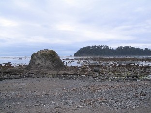
Cape Alava
The westernmost point in the Lower 48, Cape Alava lies at the end of the Coastal Trail, which starts at the Ozette visitor center.
After hiking the Coastal Trail, I spent the night at the Ozette campground, then drove back to Highway 101 and further east, until I came to the Elwha River Valley, another portion of Olympic Park. Here, I paid for two nights at the Elwha campground, then went out for some more hiking.
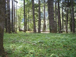
Krause Bottom
This grove of trees lies along the Elwha Trail, which starts at Whiskey Bend. The trail is actually part of a large network of trails that crisscross the entire park.
After a couple of days I left Olympic Park and went back down Highway 101 along the Hood Canal, spent a couple more days at Oxbow campground again, then went east over to Mount Rainier National Park. As usual, I first found a campsite, this time at the White River campground. Afterward, I went hiking, first on the Glacier Basin Trail, which starts at the campground itself.
Glacier Basin
This is what you find at the end of the trail. Definitely worth the hike!
The next day I drove up to the Sunrise visitor center, then took a couple more hikes.
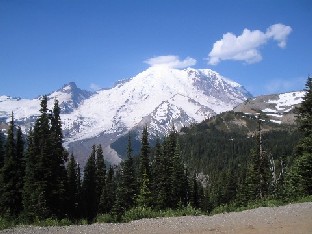
Mount Rainier from Sunrise
This is a view of Mt. Rainier as seen from the Sunrise visitor center.
The next day I left Washington and headed south into Oregon.
July 15 - 20: Oregon
Wildernet – Oregon
Travel Oregon
I didn't spend much time in Oregon, even though I like the state. After arriving on the 15th of July, I made my way to Contorta Point campground, which lies on the southern shores of Crescent Lake in the Deschutes National Forest. I spent a few days here relaxing after hiking in Mt. Rainier and before heading down to Crater Lake.
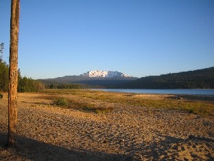
Contorta Point
This is a view along the shore of Crescent Lake at the Contorta Point campground. Note the snowcapped mountains in the background.
Crater Lake National Park was only a short drive away. The chief thing I recall about the drive itself was that the window roll down mechanism on the driver's door broke. I didn't get it fixed until I got to Tucson.
As I entered Crater Lake, I could see huge storm clouds on the horizon. The closer I got, the bigger they grew, until I was in the middle of a massive thunderstorm. I continued on around Rim Drive to Lost Creek campground, where it was still dry at the time. After pitching my tent and paying for a couple of nights, I went back out to the road.
While it was raining, I made a complete circuit of Rim Drive. This circular road goes all the way around the lake, a considerable distance. By the time I got back the rain was passing. So I went over to Mazama Village, picked up a few supplies in the general store, then took a hike in Annie Creek Canyon.
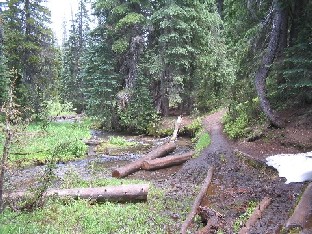
Annie Creek
This small stream meanders along the bottom of Annie Creek Canyon. It is a pleasant little hike, with only a couple of steep places, where you enter and exit the canyon. Note the snow in the picture. I saw more snow in this park than anywhere else on my trip. And this was July!
After hiking at Annie Creek I went back to the Rim Village and took a few shots.
Crater Lake
This was taken from Rim Village. Note that the sky is clearing up after the storms of the morning.
I drove around some more and took a few more short hikes before heading back to the campground.
Phantom Ship
If you look next to the big tree, in the “notch”, you will see what resembles a ship. This is actually a small island. Because of its appearance it is known as the Phantom Ship.
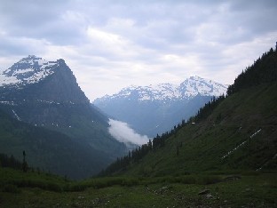
The next morning was clear, without any rain. I had seen a trail I wanted to hike, but had not had the time the day before. So this day I took the trail up to Crater Peak, a small peak a little way south of the lake itself.
Crater Peak
This is the top of Crater Peak. Note the shallow bowl that gives the peak its name. I never did find out if it was actually volcanic or not.
On the way up, I had almost been forced to turn back more than once because of trees fallen across the trail. Ironically, on my way back down I ran into a group of park employees who were clearing the trail that morning!
The next day I left Oregon for California.
July 21 - August 7: California
Wildernet – California
California Tourism
The day I entered California the weather changed, and basically never changed back. Previously, I had experienced rain at nearly every place I stopped. Now, it quit. The sun came out, and came out strong. Daytime highs near 100 degrees greeted me at my first campground. The only cooler weather came when I was at high elevations in places like Yosemite park.
My first stop was at another “old friend” campground, a small one called Norcross (see Camping Trip 2000), located a bit south of State Highway 96 out of Happy Camp, in the Klamath National Forest.. When I was there in 2000, the weather was perfect. This time, it was hot. Daytime highs hovered near or above 100 degrees. And at night it cooled only to the mid 60's. Only one evening was there even a threat of rain, as a thunderstorm passed to the east, no doubt provoked by the hot weather.
Norcross Campground
This is the entrance to Norcross. You can't see the river off to the right, or the other one that joins it up ahead where the valley forks. A trail heads up each direction.
The other thing I remember distinctly about this visit is that one evening I either caught a quick virus or else ate something I shouldn't have, because when I went to bed that night I was not feeling well. I couldn't get to sleep, and finally got up around 1:00 AM, feeling sicker than a wiener dog with worms. I immediately proceeded to puke my guts up into the woods, then made my way to the outhouse, spewing again every few steps. Fortunately, once I “emptied out”, I felt better and was able to get to sleep. The next morning I felt normal.
After leaving Norcross, I made my way back to Highway 101. South of Eureka, a portion of the four-lane highway is paralleled by the original road, called “Scenic 101” and the “Avenue of the Giants”. It is here that Humboldt Redwoods State Park is located, and I finally fulfilled a promise made to myself to return and actually stay a few nights.
I stayed a couple of nights in Humboldt Redwoods, one of the jewels of the California state park system, wanting to experience some of its nearly hundred miles of trails. Unfortunately, I wasn't able to take many pictures, because the redwoods blocked so much light that most of my attempts simply did not turn out! But I got a few.
Redwoods
This was taken from along the River Trail, a hiking trail that parallels the Eel River and Highway 101.
Temperatures were not quite as high in Humboldt Redwoods as they were at Norcross, but it still got up into the mid 80's. After a couple of days I continued south along 101 to State Highway 20, which went east, passing along the north shore of Clear Lake. On the western end I turned north into the Mendocino National Forest and spent a few nights at a campground called Penney Pines. By my standards it wasn't much of a campground or forest, but it was a place to relax.
After leaving Penney Pines I drove across the state, through Sacramento, and into the Toiyabe National Forest on the eastern side of the state. There, I stayed a couple of nights at Obsidian campground. I would have left earlier, but I was heading for Yosemite, and wanted to enter in the middle of the week, to have a better chance of finding a campsite. Obsidian is at 7200 feet, and I was surprised in the morning to find the temperature below freezing.
So, after leaving Obsidian I entered Yosemite National Park, coming in through the east entrance on Tioga Road. I did manage to find a site at the Porcupine Flat campground, one of the few remaining. I paid for three days and set up my tent, then headed back out, going east again to see some of the sights near Toulumne Meadows.
Dog Lake
This pleasant lake, situated at 9240 feet elevation, is at the end of a mile and a half trail that starts near Toulumne Meadows. Incidentally, no dogs are allowed at Dog Lake.
The second day saw more driving around and hiking along Tioga Road. I had decided to leave Yosemite Valley for the third and final day.
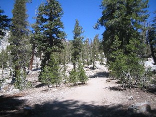
May Lake Trail
This trail leads up to May Lake, a small lake with a walk in campground on its shore. I was surprised to find running water and flush toilets when I got there.
On the last day I went down to Yosemite Valley, no doubt the best known part of the park. I had two disappointments: 1) There must have been at least 10,000 people there; it was more crowded than a city! 2) Due to lack of rain during the past five years, Yosemite Falls was merely a thin trickle, a pitiful remnant of its once glorious self.
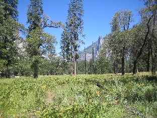
Yosemite Valley
This is a shot up Yosemite Valley taken near El Capitan.
On the way back to the campground, I stopped at Toulumne Grove to see some giant sequoias. These are some of the oldest living things on Earth.
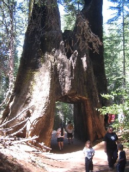
Tunnel Tree
Someone hacked a tunnel through the heart of this dead sequoia, and made a path through it. After taking the picture I wondered if the little girl in the middle thought I was taking her picture instead!
If you are interested, here is a site with some Yosemite hiking tips.
After three days of enjoying the sights and coolness (Tioga Road is over 7000 feet), I left Yosemite and went down to Death Valley. What a difference!
Death Valley National Park is a place that I would love to visit again—in the winter. The views and formations are unique and fascinating. But the tremendous heat was like a hammer blow. Someday I will go back, but in February or March, not August.
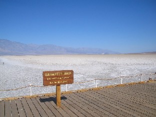
Badwater Basin
The Badwater Basin is the lowest point in the Western Hemisphere, at nearly 300 feet below sea level. Just looking at this picture makes my skin prickle with memories of heat!
Finally, after leaving Death Valley, I left California completely, passing through a corner of Nevada, through Las Vegas, across Hoover Dam at the south end of Lake Mead National Recreatino Area, and into Arizona.
August 8: Arizona
Wildernet – Arizona
Arizona Highways
Since I was heading to Tucson, I spent my last night on the road in Arizona. Originally, I had planned to go to the White Mountains and camp for several days. Unfortunately, my car had started giving me trouble in Death Valley, and it was getting worse. So I sadly decided to forego the last several planned days, and stopped at Kaibab Lake campground in the Kaibab National Forest.
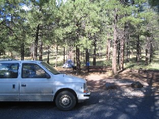
Campsite at Kaibab Lake
This was my last night on the road, so I thought I'd include this picture just to remember it.
The next day I drove through Flagstaff, then down through Phoenix, and finally into Tucson.
The Tour was over.